NSW Seamless Geology project
NSW Seamless Geology update
An update to the NSW Seamless Geology Data Package (version 2.6) was released in May 2026 and includes the following features (see the version history document for more details).
- A significant upgrade to the geological mapping of the Rockley-Gulgong Volcanic Belt (northern area).
- Comprehensive upgrade to the geology of Broughton Island.
- A significant update to the geological mapping of the Canbelego 1:100,000 map sheet area.
- Minor geology updates to the Moss Vale/Wrightville 1:100,000 map sheet areas and the Gunderbooka, Harrington and Lord Howe Island areas.
- References cited against the data consolidated into a central database and standardised using the ‘author–date’ style guide.
- Attribute updates and minor error fixes to all layers.
The dataset is also available in a single layer version, in which the various time slices have been flattened into a single layer, effectively presenting the surface geology only.
The ArcGIS and QGIS data packages are available in the GDA94 and GDA2020 datums. The MapInfo data packages are available in the GDA94 datum only.
Datasets available for viewing and download
- NSW Seamless Geology Data Package available in ArcGIS Pro (3.5 or later), MapInfo (11.5 or later) and QGIS (3.34.15 or later). A GDA2020 version of this package is also available.
- Single layer version of the NSW Seamless Geology dataset. A GDA2020 version of this package is also available.
- Viewable map on iPhone and Android phones and tablets
- NSW Seamless Geology on MinView
- A report on all updates to the NSW Seamless Geology data package since its first release in October 2018 is available in DIGS.
IMPORTANT: Esri deprecated ArcMap (as part of ArcGIS Desktop) in July 2024 and fully retired it on 1 March 2026. Maintaining the NSW Seamless Geology in ArcMap MXD format is no longer sustainable, as Esri has stopped producing updates, patches, and new licenses. The NSW Seamless Geology data packages as of this version (v2.6) are only maintained in ArcGIS Pro (ArcMap and ArcReader are no longer supported). ArcMap and ArcReader Seamless Geology data packages for version 2.1 (2021) to version 2.5 (2025) are still available to download here under the heading 'HISTORIC EDITIONS'.
Value-added and related products
Numerous products using the NSW Seamless Geology Geodatabase have been generated or are ongoing. These include:
- Quarterly Notes 158: Geological provinces and tectonic cycles in NSW – a framework for the NSW Seamless Geology dataset.
- Fault attribution work for Zone 54 (report), the eastern Lachlan Orogen (report) , the western Lachlan Orogen (report), and the Southern New England Orogen of NSW (report). All completed fault attribution data is included in the latest NSW Seamless Geology Data Package.
- Metamorphic mapping (data available in the latest NSW Seamless Geology data package):
- NSW outcrop (bedrock exposure) and soils map (data available in the latest NSW Seamless Geology Data Package).
- Integration with 3D Mapping of NSW
- Integration with Mineral Potential Mapping of NSW
- Detailed stratigraphic unit tables for all units in the NSW Seamless Geology Geodatabase – now on MinView (current best coverage is available for rock units in the Permo-Triassic basin, Delamerian Orogen and parts of the Macquarie Arc, New England Orogen, Cobar Supergroup and Fifield Suite).
What is the NSW Seamless Geology?
- An initial five-year project (2013–2018) to complete Version 1 of the statewide product.
- Joins the best-available geological mapping (on a variety of scales) across NSW.
- Connects line mismatches (e.g. geological boundaries, faults etc.) across existing geological map sheet boundaries.
- Harmonises stratigraphic units across NSW.
- Forms an integral part of ongoing work such as 3D, mineral potential and metamorphic mapping across NSW.
- A continuously updated dataset, with new versions released annually.
- For a detailed explanation of the methods used in the NSW Seamless Geology Project, see the Quarterly Notes 145 of the Geological Survey of NSW (GSNSW).
Features of the NSW Seamless Geology dataset
- Data is presented as a series of lithotectonic layers/provinces that form geological time-slices (see figure below), ranging from the Palaeoproterozoic structural and metamorphic evolution of the Broken Hill Block, to the Quaternary depositional systems of the east coast.
- It includes extensions of outcropping geology undercover (i.e. solid pre-Permian basement beneath younger sedimentary basins and unconsolidated sediments).
- A standard database structure and schema contain comprehensive attribute tables for each stratigraphic unit, enabling detailed querying and extraction of datasets such as geology, structure, metamorphism and geochronology.
- Free download is available in a variety of formats including GIS, mobile phone maps and online portals.
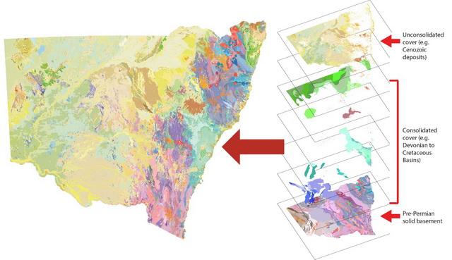
The NSW Seamless Geology dataset composed of lithotectonic layers/provinces
We would like your feedback
The NSW Seamless Geology dataset is compiled from the best available mapping - mostly from the GSNSW, with some thesis mapping. The data is continuously improved by fixing identified issues, future GSNSW mapping programs and incorporation of better-quality company or thesis mapping, with periodic updates to improve the NSW Seamless Geology dataset.
Our aim is to make this dataset the authoritative source of geology for NSW.
So, if you find a problem or if you know of better mapping - please let us know.
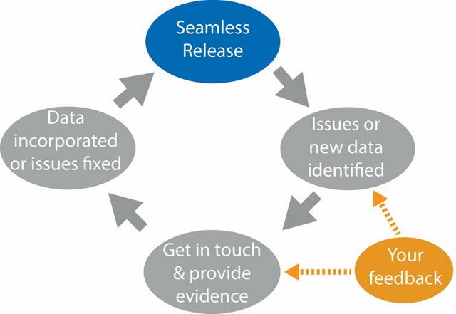
NSW Seamless Geology project workflow
Contacts
james.ballard@dpird.nsw.gov.au