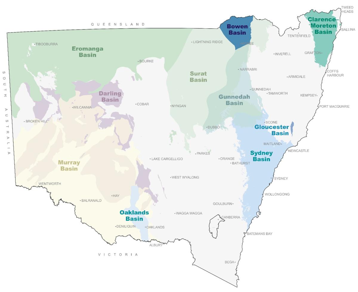
Sedimentary basins
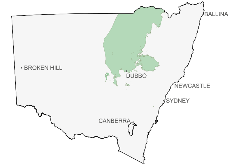
Over 60 per cent of the state is covered by sedimentary basins. In the east, the coal rich Permian to Triassic Sydney–Gunnedah–Bowen Basin system is partially overlain by the Jurassic to Cretaceous Great Australian Basin, comprising the Surat Basin and Eromanga Basin. The Triassic to Jurassic Clarence–Moreton Basin extends from north eastern NSW into southern Queensland. To the west, the largely Devonian Darling Basin is overlain by the Great Australian Basin and the Cenozoic Murray Basin.
The basins are separated into layers/provinces that form geological time-slices in the NSW seamless geology dataset:
- Western Devonian Basins (e.g. Darling Basin)
- Permo-Triassic Basins (e.g. Sydney and Gunnedah basins)
- Great Australian Basin (e.g. Eromanga, Surat and Clarence-Moreton basins)
Figure 1 Outcropping sedimentary basins in NSW
Clarence–Moreton Basin
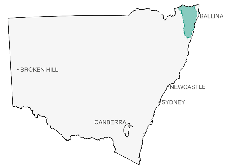
The Clarence–Moreton Basin is in the Northern Rivers region of NSW. The NSW Government policy is that there will be no further petroleum or gas exploration or production in the Northern Rivers region of NSW.
The Clarence–Moreton Basin is an intra-cratonic Mesozoic basin located onshore and offshore in northeastern New South Wales and southern Queensland. The basin is filled with mostly fluvio-lacustrine sedimentary rocks deposited in a large intramontane depocentre with thicknesses reaching 4 km in the central part of the basin.
Darling basin
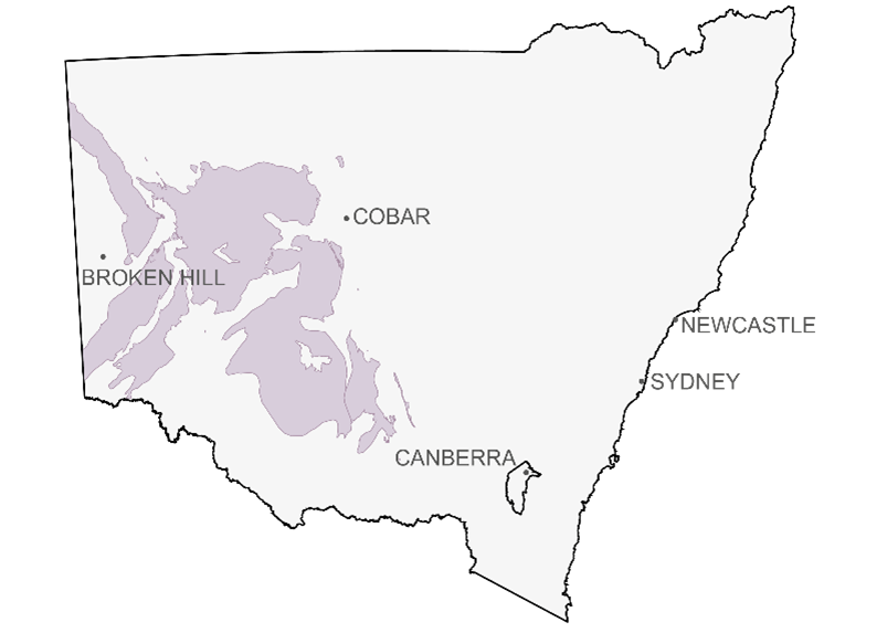
The Darling Basin, located in western-central New South Wales, is an intra-cratonic and highly structured depositional centre filled with mostly Devonian sedimentary rocks reaching up to 8 km in thickness. The Darling Basin is overlain by the Mesozoic Eromanga Basin to the north and by the Cenozoic Murray Basin to the south. Covering an area of over 100,000 km2 it is one of Australia's largest underexplored basins.
Modern A 3D structural framework of the basin was developed using aeromagnetic, gravity and seismic data (2,000 km of modern multi-fold seismic data was recently acquired by the Department and has been supplemented by reprocessed old seismic data).
Eromanga basin
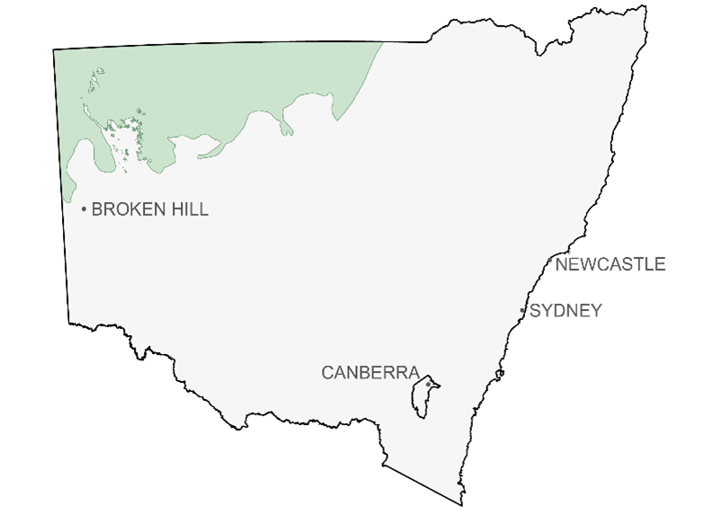
The Mesozoic Eromanga Basin, located in far northwestern New South Wales, represents the shallower shelf areas of the much larger Great Artesian Basin. The New South Wales area is considered distal from the recognised main sediment source, associated with major depocentres in South Australia and Queensland.
Recent re-processing of existing geophysical data and newly acquired seismic data has led to the recognition of troughs underlying the Eromanga Basin including the Paka Tank and Urisino troughs.
Gloucester Basin
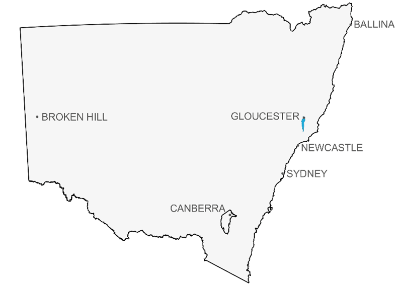
The Gloucester Basin is a relatively small Permian sedimentary basin, approximately 40 km long and 10 km wide with a total area of 380 km2. The basin occupies the northern end of the north-south trending Stroud-Gloucester Syncline, about 100 km north of Newcastle.
The Gloucester Basin contains about 4,000 metres of sedimentary rocks. There are three major stratigraphic units in the basin. The Early Permian Stroud Volcanics/Alum Mountain Volcanics contains a sequence of volcanic rocks, fluvial deposits and coal. This unit is overlain by Late Permian Dewrang Group and the Gloucester Coal Measures. The Dewrang Group is about 600 m thick and contains fluvio-deltaic deposits with coal seams up to 10 m thick.
Gunnedah–Bowen Basin
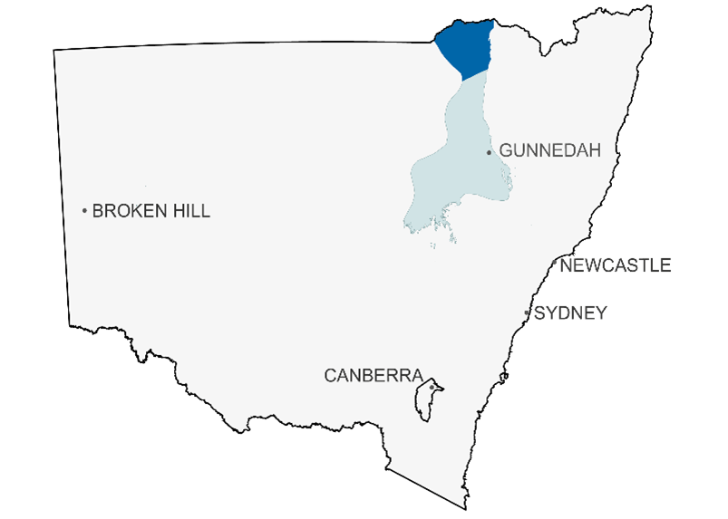
The Gunnedah–Bowen Basin is part of the Sydney–Gunnedah–Bowen Basin system, a major basin system which extends from southern coastal New South Wales to central Queensland. The Gunnedah–Bowen Basin covers an area of just over 15,000 km2, overlies part of the Palaeozoic Lachlan Orogen, and is overlain on the north and west by the Surat Basin.
The Permo-Triassic Gunnedah Basin hosts two main coal measure sequences, the Blackjack Group and the Maules Creek Formation. The coal produced is bituminous coking and thermal coal. The quality of thermal coal ranges from medium to high ash, low sulfur coal to low ash, high energy, export quality coal. Coking coal, used for iron and steel production, supply both the export and domestic markets.
Oaklands Basin
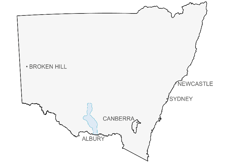
The Oaklands Basin is a Permo-Triassic sedimentary basin located near the major towns of Albury and Griffith in the Riverina district of southern New South Wales. It covers an area of about 3,800 km2 and has a postulated maximum depth of 1,700 m to 2,000 m. The basin extends north-northwest over approximately 120 km and is approximately 50 km wide. It lies beneath the eastern portion of the Cenozoic Murray Basin.
The structural framework of the basin is poorly understood and little is known about pre-Late Permian stratigraphy, unit distribution or facies development.
Murray Basin
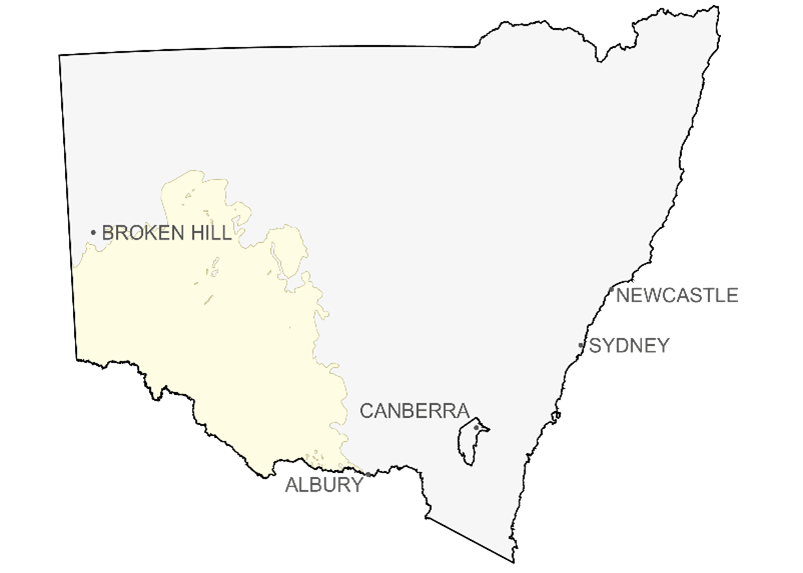
The Murray Basin of south-western NSW covers an extensive area extending into Victoria and South Australia. The Murray Basin refers to a widespread thin sequence of Cenozoic consolidated and unconsolidated sediments. However, the basin overlies several basement depressions that appear to be mainly deep grabens and half grabens, as well as shallower gentle basement downwarps; all containing Palaeozoic and Mesozoic sedimentary rocks.
The Murray Basin contains extensive occurrences of fluvial, estuarine, beach and marine sediments of Palaeogene and Neogene age. The rocks are generally undeformed, and contain brown coal deposits and major concentrations of heavy minerals (rutile and zircon).
Surat basin
The Surat Basin of northern New South Wales is part of the Great Artesian Basin, a large Jurassic–Cretaceous intra-cratonic basin that covers 1.7 million km2 of eastern Australia. In NSW, the Surat Basin covers an area of 270 000 km2 and has a maximum thickness of approximately 1.8 km in northern NSW.
The basin unconformably overlies the early to late Palaeozoic Lachlan Orogen in the western to central part of the basin, and in the east overlies the Permian to Triassic Sydney–Gunnedah–Bowen Basin system. Palaeozoic basement highs, the Nebine Ridge and Kumbarilla Ridge respectively, mark the basin's boundaries with the Eromanga Basin to the west and the Clarence–Moreton Basin to the east.
Sydney basin
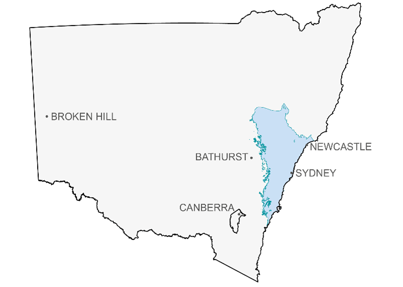
The Sydney Basin is part of the Sydney–Gunnedah–Bowen Basin system, a major basin system extending from southern coastal New South Wales to central Queensland. The total onshore area of the Sydney Basin is approximately 44,000 km2 with an offshore component of about 5,000 km2. The Sydney Basin overlies the Early to Middle Palaeozoic Lachlan Orogen.
The Permo-Triassic Sydney Basin hosts four coal measure sequences, namely the Greta, Tomago/Wittingham, Illawarra and Newcastle coal measures. Coal is extracted from four coalfields within the basin: Hunter, Newcastle, Western and Southern.
The coal produced is bituminous coking and thermal coal. The quality of thermal coal ranges from medium to high ash, low sulfur coal used for domestic power generation and cement manufacture; to medium to low ash, high energy, export quality coal. Prime, low volatile, hard coking coal and low ash, semi-soft coking coal, used for iron and steel production, supply both the export and domestic markets.
For further information
Contact Resource Assessment and Advice